Data as at 14 September 2026 · from the Queensland EP Act public register
P-PRCP-100779213 · BHP COAL PTY LTD
PRC plan P-PRCP-100779213 for BHP COAL PTY LTD (EPML00853413), coal. Current schedule final milestone 2148-12-10; 12 rehabilitation and improvement areas. 1 applications, including information requests and replies.
- Environmental authority
- EPML00853413
- Holders
- BHP COAL PTY LTD; BHP Queensland Coal Investments Pty Ltd; Mitsubishi Development Pty Ltd; QCT INVESTMENT PTY. LTD.; QCT MINING PTY. LTD.; QCT RESOURCES PTY LIMITED; Umal Consolidated Pty Ltd
- Tenures
- ML1763; ML1764; ML1802; ML1900; ML700003; ML70121; ML70193; ML70194; ML70287; ML70288; ML70289; ML70421; ML70468; ML70469; ML70478; ML70479; ML70493; ML70494
- Plan versions
- P-PRCP-100779213 (effective 2025-11-04)
- Current schedule final milestone
- 2148-12-10
- Areas in current schedule
- 12 · 12,508 ha
Schedule versions
| Version | Effective | Final milestone | Areas | Document |
|---|---|---|---|---|
| 1 (current) | 2025-11-04 | 2148-12-10 | 12 | Schedule PDF |
Rehabilitation and improvement areas
From the current schedule's tables. Land use categories are keyword groupings; the schedule's wording is shown beneath.
| Area | Activities | Hectares | Post-mining land use | First milestone | Page |
|---|---|---|---|---|---|
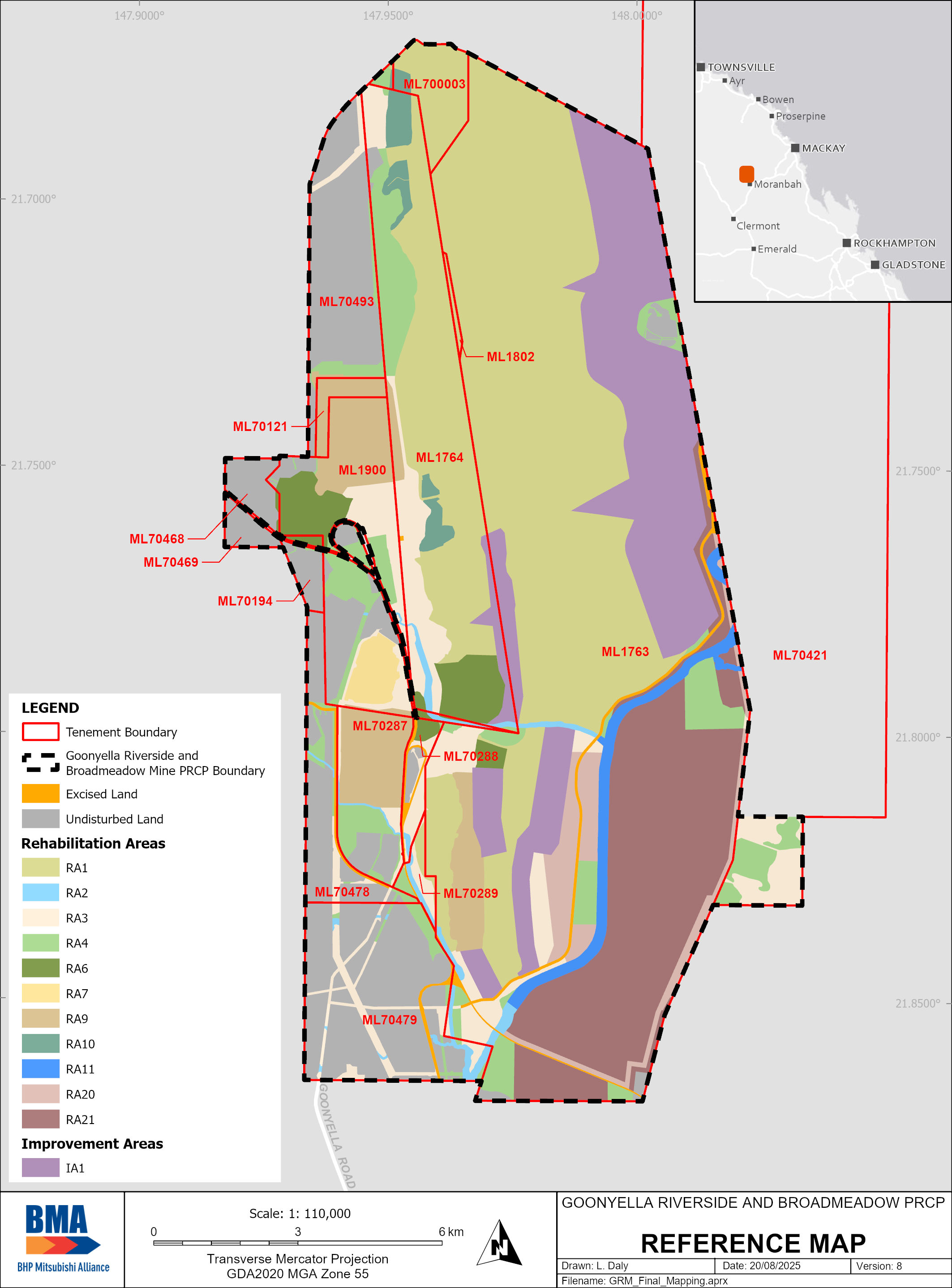
| RA1rehabilitation | Spoil Dumps | 5557 | Native ecosystemWoodland Habitat | 10/12/2025 | 11 |
| RA2rehabilitation | Watercourse Diversions and Crossings | 173 | Water, diversions and flood landformsWatercourse | 10/12/2061 | 13 |
| RA3rehabilitation | CHPP, workshops, fuel/oil/chemical storage, buildings, train load outs, dams, coal stockpiles, roads, general infrastructure and disturbance | 1286 | GrazingCattle Grazing | 10/12/2061 | 14 |
| RA4rehabilitation | Roads, laydown areas, conveyors, general infrastructure and disturbance, Area 4 | 1165 | Native ecosystemWoodland Habitat | 10/12/2061 | 16 |
| RA6rehabilitation | Reject dumps | 400 | Native ecosystemGrassland | 10/12/2031 | 18 |
| RA7rehabilitation | Existing Rehabilitation | 118 | GrazingCattle Grazing | 10/12/2024 | 19 |
| RA9rehabilitation | Tailings Storage Facilities | 872 | Native ecosystemGrassland | 10/12/2033 | 20 |
| RA10rehabilitation | Existing Rehabilitation | 175 | Native ecosystemWoodland Habitat | 10/12/2024 | 22 |
| RA11rehabilitation | Watercourses, watercourse diversions and crossings within underground mining/subsidence area | 249 | Water, diversions and flood landformsWatercourse | 10/12/2057 | 23 |
| RA20rehabilitation | Subsidence, underground mining infrastructure, general infrastructure and disturbance within underground mining area | 434 | GrazingCattle Grazing | 10/12/2057 | 24 |
| RA21rehabilitation | Subsidence, underground mining infrastructure, general infrastructure and disturbance within underground mining area | 2079 | Native ecosystemWoodland Habitat | 10/12/2057 | 25 |
| IA1improvement | Residual Voids | NUMA or voidNUMA | 10/12/2032 | 45 |
Application A-PRCP-NEW-100779183
- Received
- 2024-11-29
- First information request
- 2025-03-04
- Response due
- 2025-09-05
- Extensions
- 2 (to 2025-03-04)
- Plan effective
- 2025-11-04
- Days from receipt to plan effective
- 340
- Register
- Application record
16 documents on the register
- A-PRCP-NEW-100779183_ApplicationDocuments Other
- A-PRCP-NEW-100779183_ApplicationDocuments_Attachment_01 Other
- A-PRCP-NEW-100779183_ApplicationDocuments_Attachment_02 Other
- A-PRCP-NEW-100779183_ApplicationDocuments_Attachment_03 Other
- A-PRCP-NEW-100779183_ApplicationDocuments_Attachment_04 Other
- A-PRCP-NEW-100779183_ApplicationDocuments_Attachment_05 Other
- A-PRCP-NEW-100779183_ApplicationDocuments_Attachment_06 Other
- A-PRCP-NEW-100779183_InformationRequest_ExtNotice_01 Extension notice
- A-PRCP-NEW-100779183_InformationRequest_ExtNotice_02 Extension notice
- A-PRCP-NEW-100779183_InformationRequest_Notice Information request
- A-PRCP-NEW-100779183_InformationResponse Information response
- A-PRCP-NEW-100779183_InformationResponse_attachment_01 Response attachment
- A-PRCP-NEW-100779183_InformationResponse_attachment_02 Response attachment
- A-PRCP-NEW-100779183_InformationResponse_attachment_03 Response attachment
- A-PRCP-NEW-100779183_InformationResponse_attachment_04 Response attachment
- A-PRCP-NEW-100779183_InformationResponse_attachment_05 Response attachment
Information request: 62 items
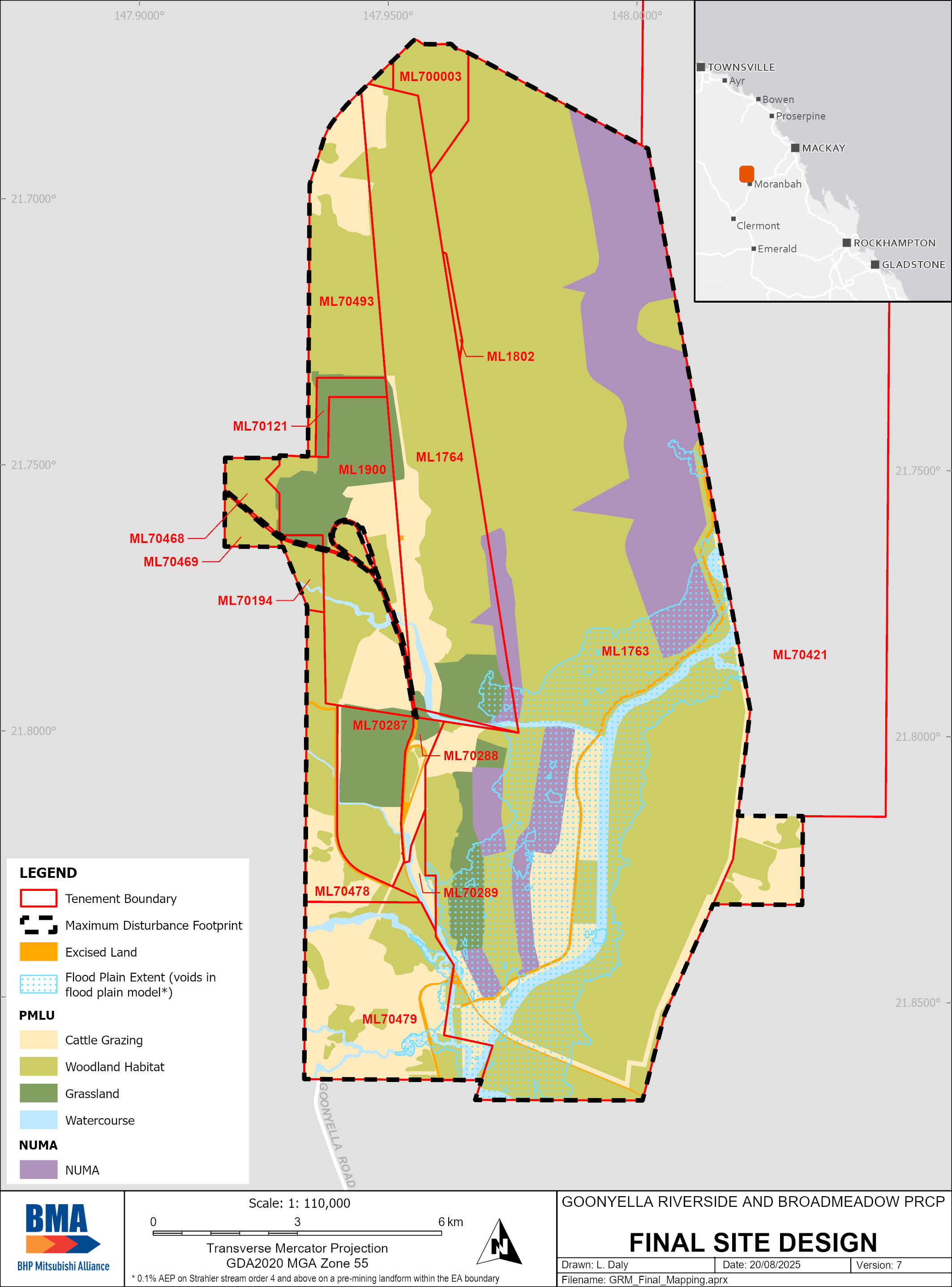
Department foundMissing specifications - Spatial • The spatial identifies the only sensitive receptors as ‘watercourse’. • The areas affected by both open cut and UG disturbance are not clearly identified. For example, the above ground overburden area and NUMA that likely to be affected by subsidence are not clearly shown under ‘subsidence’ layer in spatial data. (Refer to below images) • The NUMA area and improvement area are identified in one polygon, but the polygon does not delineate between the NUMA components such as the void water body, high-wall area, safety bund area. • Voids in the floodplain are shown however the entire extent of the floodplain (that is other areas of mine that could potentially be affected by the floods or are within the floodplain) is not shown. Subsidence impact in PRC plan and in spatial data Missing specifications – Table and Figure PRC Plan Table 2: Primary mine features at GRM & BRM lists the mine domains and their description. The mine domains can be inferred as referring to all relevant activities that is ERA 13: Coal mine and ancillary ERAs such as STP and mineral processing and chemical storage etc. Table 2 and Figure 3: GRM & BRM site map, do not clearly categorise mining domain and their description under title of ‘relevant activities’. The PRC plan Table 12: Relevant activities requiring rehabilitation outlines the predicted duration for the ‘Spoil dump’ domain however other domains are specified generally as ‘until the end of rehabilitation’, thus no specific duration for relevant activity provided. The end of rehabilitation activity may be until end of mining or beyond that, inferring the relevant activity duration to be beyond mining, which could be incorrect. The PRC plan Table 19 provides a summary of progressive rehabilitation until 2059. It is noted that life of mine for GRM is 2059 but some components of GRM will not be rehabilitated or surrendered at 2059 due to connecting operation of RHM. As such, further information is needed to understand rehabilitation planning until planned surrender which could be at closure of RHM (2094).
Asked forProvide a spatial data – a) That clearly shows areas that are affected by overlapping opencut and UG disturbance. b) That clearly delineates each NUMA area components including void, high-wall, safety bund and other critical components; and c) Polygons depicting the full floodplain extent to support a comprehensive flood risk assessment for the entire site. d) Showing all sensitive receptors. Provide revised PRC plan – e) Table 2 and Figure 3 clearly showing mining domains under title of ‘relevant activities’, f) Table 12 to clearly specify predicted duration of each relevant activity in its active phase and duration required for its rehabilitation; and g) Table 19 to provide progressive rehabilitation till 2094.
Department foundWater management Both sections state that seepage from mine waste (TSF, rejects, MIA) and spoil areas is predicted to be captured by residual void. The section does not provide sufficient information on pro-active and reactive measures to be adopted to monitor and ensure the flow of seepage is directed towards residual voids.
Asked forProvide a revised PRC plan inclusive of – a) A description of proactive methods adopted to control the seepage direction and manage any deviations, b) Intervention and control measures to monitor and ensure seepage flows towards residual voids; and c) A monitoring and control strategy for seepage pathways, designed to maintain alignment with the intended landform drainage design.
Department foundGroundwater monitoring data Section 8.6 states that groundwater monitoring data currently held for the site is not suitable for the development of site- specific criteria. Appendix D Hydrogeology, section 8.0 provides a summary of groundwater quality data across the project site collected through the existing groundwater monitoring network. Appendix D section 7.1 notes that there are 46 monitoring sites (it is assumed these are bores) but there is very little detail in regard to these bores. Additionally, of the 46 monitoring bores, hydrographs are presented for only 5 bores in section 7.3. A table should be included identifying each monitoring bore, its drilled date, ground elevation, depth, screened depth, geologic unit monitored and length of record available for water level and water quality data. This will provide a much clearer understanding of the groundwater monitoring data available to support the assessment. Understanding the data available from the monitoring bore network is important in understanding what data supports the groundwater assessment and modelling. Appropriate groundwater parameters and limits must be included in the PRCP schedule. Site-specific values based on site specific monitoring data are required to determine appropriate milestone criteria. This will help inform the schedule requirements to also reflect default WQOs and ANZG 2018 values which will be imposed as limits. Quality characteristics should be based on relevant contaminants of concern (CoC). CoC should be the same for surface water and groundwater and be based on mining process (dams and seepage) and waste characterisation. At least 8 data points are required to determine site-specific values in most cases. For groundwater, the 95th percentile of baseline (ideally pre mining) data can be used to determine site- specific limits for all indicators. As per the Groundwater Guideline if there are less than 8 data points or the site-specific value is less than the default ANZG 2018 value, then the default guideline value is applied as a limit. See DES 2021 Groundwater Guideline - https://www.publications.qld.gov.au/dataset/groundwater-quality- assessment-guideline/resource/472cc88a-000a-4bb8-a60d- 204cfe7e0238
Asked forProvide a revised PRC plan and Appendix G –that includes - a) A revised table with details of all monitoring bores including drilled date, ground elevation, depth, screened depth, geologic unit monitored, length of record available for water level and water quality data, b) Additional hydrographs from existing monitoring bores, and c) Identification of the relevant contaminants of concern (CoC) for the site.
Department foundGroundwater Dependent Ecosystems (GDEs) It is noted in section 1.2.5.5.that the Isaac River and its tributaries have terrestrial ecosystems present which are potentially facultative GDEs. However, the PRC plan does not identify these potential GDEs or outline how watercourse monitoring will be undertaken so that any impacts on GDEs resulting from post closure changes in water balance, surface water and groundwater interactions due to rehabilitated landform and NUMA.
Asked forProvide a revised PRC plan and Appendix G which - a) Identifies potential GDEs; and b) Commits to implement the necessary monitoring designed to detect change in GDE health resulting from post closure groundwater impacts due to final rehabilitated landform and NUMA.
Department foundGroundwater extraction volumes The section states that, ‘The goaf K and S parameters were adjusted by comparing computed extracted groundwater volumes from the goaf areas to the measured and recorded groundwater ingress pumped from the underground between 2018 and 2023’. Apart from an estimated groundwater inflow to Broadmeadow underground for 2020-21 in Table 16 there does not appear to be any measured and recorded groundwater ingress pumped from the underground between 2018 and 2023 provided in the report. These figures should be provided to demonstrate how the model was able to simulate these figures.
Asked forProvide a revised Appendix D inclusive of - a) Measured and recorded groundwater ingress pumped from underground between 2018 and 2023; and b) A comparison of recorded ingress with the model stimulated extraction volumes.
Department foundTransient data hydrographs Section 14.3.3 states that, ‘The transient water level data recorded between 2020 to 2024 is presented in hydrographs with the model simulation results. The hydrographs indicate trend matching across the model domain (Figure 33).’ Figure 33 provides transient hydrograph examples and only four examples are provided. This compares with the 50 bores used to provide target heads as advised in section 14.3. Transient calibration hydrographs should be provided for all target bores. Additionally, there is a concern about the match between the four example calibration hydrographs provided and the data provided in Appendix C. As an example, in the calibration hydrograph provided in Figure 33 for GW004B (extract below), the difference between the observed and model simulated water level elevations appears to be about 16 – 17 metres for each observation. However, in Appendix C (extract also below) the 6th column of the table appears to report the residual between the observed and simulated levels which appear to range from 0.5 to 2.3 m for this bore. These same issues appear to exist with the other three bores where calibration hydrographs are presented. This provides doubt as to the calibration results reported.
Asked forProvide a revised Appendix D inclusive of - a) Calibration hydrographs for all target bores used in the transient calibration. b) A comparison and discussion of the example calibration hydrographs in Figure 33 of Appendix D and the information provided in Appendix C.
Department foundModel limitations Appendix D, Table 23 Groundwater model classification table, identifies that there is an inadequate distribution of data. Considering the above, the limited groundwater level data being available in the area of the Redhill mine, and the lack of monitoring bores adjacent the Broadmeadow underground mine as discussed in Section 7.3.4, there should be more discussion of what limitation this places on the modelling.
Asked forProvide a revised Appendix D inclusive of - a) A discussion in section 14.5 on the limitations that existing groundwater level data places on model calibration and how the limited existing groundwater level data impacts model predictions including the post mining predictions of connection between the underground mines and the residual voids.
Department foundGroundwater elevation contours Figure 39 presents predicted groundwater elevation contours at the start of predictive modelling from 2024. However, the contours are difficult to interpret in the mine impacted areas because of the large area the contours cover. Additional contours zoomed into the mine areas would assist in interpretation.
Asked forProvide a revised Appendix D inclusive of - An updated Figure 39 with some additional contours over a smaller area which provides more detail around the mine leases for the predicted groundwater elevations at the start of the predictive modelling.
Department foundGoonyella residual void predicted water level The section states, ‘Pseudo-steady residual void water level is around 20 mAHD (> 100 m deeper than other residual void water levels).’ This generally agrees with Appendix O Table 4.1 which states the modelled mean void water elevation is 21 m AHD. However, Plate 39 in Appendix D Section 15.4.2.6 appears to have an error throughout the graphs as the average water level appears to be plotted at about 2 m AHD. An extract from Plate 39 is provided below. It is important that accurate information is plotted on the graphs when predicting the flow of water between the aquifers and the residual voids.
Asked forProvide a revised Appendix D inclusive of - Review of section 15.4.2.6 and Plate 39 and Appendix O to provide consistent advice on the modelled average water level in Goonyella residual void post closure.
Department foundPredicted groundwater drawdown Figure 46 provides three sets of contours, starting simulated groundwater elevations in layer 1, and then predicted changed water level (drawdown) in layer 1 at the end of P3 and at the end of P4. The predicted changes in water level are presented in 20 m interval contours. These contours are too coarse to provide any detail around the Isaac River alluvium. Additionally, the areal extent of the contours are too wide to allow a detailed understanding of predicted changes in water level around the mine leases.
Asked forProvide a revised Appendix D inclusive of - Updated Figure 46 showing predicted changes in water levels in layer 1 over a zoomed in area around the mine leases and with contour intervals of 1 m.
Department foundPredicted groundwater drawdown Figure 66 provides changes in surficial sediments water level from the initial 2024 levels at the end of 2199 in m. This figure is used in Section 15.8.2 to discuss potential impacts to GDE’s. However, the change in water level contours are presented in 20 m intervals. Additional change in water level contours should be provided for the area around the mined area and at 1 m contour interval to more clearly understand impacts in the surficial sediments adjacent the mine leases.
Asked forProvide a revised Appendix D inclusive of - Additional change in water level contours in the surficial sediments, for the area around the mine leases at 1 m contour intervals.
Department foundPredicted long term groundwater flow Figure 47 shows change in water level contours at the end of P4 (year 2199) layer 10, GMS (Goonyella Middle seam). These contours demonstrate a long-term drawdown of 100 m extending off to the north-east of Redhill Mine, extending to what appears to be the model boundary in that direction. However, in the report there appears to be no predicted long term groundwater elevation contours provided for the Goonyella Middle seam which captures the full Redhill Mine area and the model area to the north-east. These contours are required to demonstrate the predicted long term groundwater flow direction around all parts of the Redhill Mine and its connection with the Goonyella Riverside residual voids and underground mines post mining.
Asked forProvide a revised Appendix D inclusive of - Predicted post mining equilibrium groundwater elevation contours for layer 10, Goonyella Middle Seam which demonstrate predicted groundwater flow direction from all areas of proposed mining in the Red Hill mine and Goonyella Riverside mine areas.
Department foundGoonyella residual void modelled depth and average water level Appendix O appears to provide no detailed information about the elevation of the base of the Goonyella residual void used in determining the modelled average void water levels. In Appendix D, Section 15.4.2.6, in relation to Goonyella residual void northern section initially, and then the middle section of the void, it states: ‘Note: The pit floor is some -35 mAHD at this location, the pit floor adopted in the residual void (surface water) water balance model is set at a uniform -45 mAHD (it is assumed that the specialist modellers used the deepest pit floor elevation in their water balance model)’. This results in the water level dip or decrease at the start of the water level hydrographs when the groundwater model drain cells (at bottom of pit) are changed to CHD and adopt the predicted water balance model pit water levels (Section 15.4.1). This dip in the water level hydrographs is recognised in all of the hypothetical observation point hydrographs. This is particularly evident in the middle set of hydrographs where the Goonyella open cut mine only extends to a depth of around 25 mAHD in this area (mining is shallower in this area due to environmental constraints in this area). It appears then that the Goonyella residual void has been modelled in Appendix O as having a uniform void base of -45 m AHD when in places it will be higher than this and in the middle as high as +25 m AHD. It is not clear how this has impacted the modelled void water level? Is it possible that by using a deeper base for the void, than actually will exist, the modelled void water level is lower than that which will actually result. The PRC plan section 4.3 states that Goonyella void will be partially backfilled at the northern end, it is not clear if the above modelling has considered the void base after the intended backfill level. Further clarification is needed to understand how the consideration of deeper base for void and partial backfill of the void for flood mitigation purposes might impact sink/ source relationships.
Asked forProvide a revised Appendix O inclusive of - a) Clarification if the modelling of Goonyella residual void with a uniform base is considerate of proposed backfill of the void at the northern end; and b) Information on how the modelling of Goonyella residual void with a uniform base of -45 m AHD may impact the modelled average void water level and the void behaviour predictions as a sink.
Department foundModelling Section 6.1.2.1 indicates that, ‘Three climate change scenarios (6%, 11% and 20% increase in rainfall intensities) were also run for the 0.1% AEP’. The Australian Rainfall and Runoff (ARR) guideline states ‘for flood stimulation, all flood estimations must include the impact of climate change, maps without integrated climate change impacts are not required to be presented’. Further clarification is required to confirm if the flood stimulation undertaken for the PRC plan aligns with the above-mentioned ARR guideline.
Asked forProvide a revised PRC plan inclusive of – A clarification of whether all three climate change scenarios included in the flood stimulation as per PRC plan section 6.1.2.1, include the impacts of climate change as per the ARR guideline.
Department foundFlood flow force along diversions The Appendix H shows that shear stress in Eureka Creek exceeds 80 N/m² during even a 2% AEP flooding, which poses a significant risk of ingress into Ramp 2 void. Further, under PMF conditions, there is confirmed ingress into Ramp 2. It seems the presented maps, assume stability of the diversion during 2% and 0.1% AEP, despite high erosive forces, and assumes stability of the diversion in the PMF event even in the case of overtopping. The Watercourse Diversion Guideline mandates integration of sediment regimes into analysis, which appears to be absent. Sediment hydraulic forces should be clearly considered in the modelling to completely understand the risks to the landform during flood event. Also, in relation to Ramp 2, it is important to clarify whether tailings material will be present and exposed to ingress. The PRC plan should address PMF design for closure, per the mandated requirements of ANCOLD 2012. 0.1%AEP depth (left), 0.1%AEP velocity (right): PMF depth:
Asked forProvide a revised Appendix H inclusive of – a) A detailed analysis of how high shear stresses (>80 N/m²) are managed to prevent erosion and void ingress during 2% and 0.1% AEP events, b) Modelling that considers sediment hydraulic forces using the TUFLOW sediment module; and c) Mitigative measures to prevent ingress and subsequent contamination, in relation to any tailings material present for Ramp 2.
Department foundFlood ingress into pits and interaction with TSF The PMF scenario results in void ingress, i.e., into Ramp 2 (airstrip), Goonyella pit, and R32 Satellite (APPENDIX B1-2-4, APPENDIX B3-2-4). With respect to the interaction of flood waters with the TSF and void, section 5.5.1 states that the R32 residual void is subject to inundation from the R32/Airstrip TSF facility rehabilitated surface to the north and Isaac River from the south in PMF events. In conclusion, PMF influences and inundates TSF R32 and R32 Satellite pit (APPENDIX B1-2-4, APPENDIX B3-2-4). To ensure compliance with section 126C(1)(j) of the Environmental Protection Act 1994, provided information must demonstrate how the final landform is designed to be safe and stable. Information expanding on whether the ANCOLD 2012 guideline has been considered, and an explanation on how the design flood was considered for protecting TSF to avoid environmental risks will help in demonstration of safe, stable final landform design. Risk management strategies for void ingress under PMF conditions must be clearly explained, including measures for minimising flood ingress and mitigating associated risks of contamination with specific reference to waste material characterisation is needed.
Asked forProvide a revised Appendix H inclusive of – a) Consideration to ANCOLD 2012 guideline and explanation on how the design flood was considered for protecting TSF to avoid environmental risks, b) Risk management strategies for void ingress under PMF conditions, c) Management measures to minimise flood ingress; and d) Mitigative measure for contamination risk in consideration to ingress and in-pit waste material characterisation.
Department foundFlood modelling adjustments due to subsidence impact Subsidence generally alters the topography of a landscape and affects flood behaviour. Subsidence is expected across portions of the Broadmeadow Underground Mine and therefore a re- evaluation of flow velocities and depths post-subsidence will be required to understand flow paths and any implications for diversions and NUMAs. This should also include an assessment determining the requirement for additional flood mitigation measures, due to changes in topography.
Asked forProvide a revised Appendix H inclusive of – a) Detailed information on the effect of subsidence-induced changes to overland flow paths impacting diversions and NUMAs. b) An assessment of the need to implement any flood mitigation measures as a result of subsidence – induced changes discussed in part a).
Department foundDiversion rehabilitation The concept reports for Isaac River, Holding Paddock, Fisher and Eureka Creek diversions exhibit significant gaps when evaluated against the provided Watercourse Diversion Guideline. The reports fall short in addressing design elements for ensuring hydrological, geomorphic, and hydraulic stability as outlined in the Watercourse Diversion Guideline and the key design considerations. These gaps could compromise the long- term functionality, self-sustainability, and regulatory compliance of the diversions. Immediate focus is needed to incorporate detailed assessments and robust design measures to address these deficiencies. It must be noted that diversions are part of the final landform and under PRCP guideline section 3.1 outlines the need to provide information about how progressive rehabilitation and closure will achieve a stable condition, which includes ensuring safety, structural stability, and environmental compliance of the final landform, this is to be aligned with 126C(1)(j) EP Act 1994.
Asked forProvide revised PRC plan/relevant appendix inclusive of information on – a) Rehabilitative design elements for diversions ensuring hydrological, geomorphic, and hydraulic stability as outlined in the Watercourse Diversion Guideline; and b) Rehabilitation criteria based on SMART principles for diversions targeting hydraulic stability, sediment management, and vegetation integration to achieve safe, stable, non-polluting landform. Example includes but not limited to – • Criteria for flood plain development, • rock armouring of diversion channels if required at high erosion prone areas etc.
Department foundIn accordance with the Watercourse Diversion Guideline, the proposed diversions must: • maintain the natural hydrological and hydraulic characteristics of the original watercourse, • maintain natural geomorphic and riparian vegetation similar to the original watercourse, • maintain a sediment transport regime, with minimal impact on sediment deposition or erosion, • achieve equilibrium condition, • minimise erosion, and do not increase flood risks. • provide an appropriate floodplain corridor width to accommodate natural processes • be designed to be self-sustaining, with minimal ongoing maintenance, • be integrated into the overall rehabilitation plan. • be considered in floodplain modelling regarding the impact of diversions on flood behaviour, ensuring stability of the final landform design. • have structural stability analysis if is located through spoil • be designed to be hydraulicly and structurally stable e.g., armouring The proposed rehabilitation criteria for diversions and given information through the concept design reports lack adequate provisions for – o hydraulic stability, o sediment management, and o vegetation integration. To comply with the Watercourse Diversion Guideline, design plans must demonstrate that the diversions will be self- sustaining without requiring ongoing maintenance. It is essential to address critical gaps in floodplain width, ingress prevention, and structural and erosional stability to ensure they meet long-term functional and environmental outcomes.
Asked forProvide revised PRC plan/relevant appendix inclusive of information on – Rehabilitation criteria for creek diversion addressing: o floodplain width, o prevention of floodwater ingress to nearby landforms, and o structural and erosional stability of diversion banks.
Department foundStability of diversions considering subsidence impact The Isaac River Diversion (Stream Order 6) and Eureka Creek Diversion are located in areas affected by subsidence from Broadmeadow UG mining. Subsidence poses risks to achieving a stable post-mining land use (PMLU) due to: • Channel instability from deformation, erosion, and altered hydraulic connectivity. • Disruptions to sediment transport, increasing deposition and erosion risks. • Bank instability, reducing the ability to sustain riparian vegetation. Additional subsidence after mine flooding is identified as a potential concern. Also, report suggests that consolidation of caved rock after flooding may increase subsidence beyond initial estimates, but this effect does not seem to be included in the subsidence model.
Asked forProvide a revised PRC plan or relevant appendix which clarifies – a) How the PRC plan and PRCP schedule incorporates subsidence related assessments into the final diversion design, b) How the PRC plan satisfies EA Schedule J: Watercourse Subsidence, specifically: o demonstrate how the Subsidence Management Plan assesses subsidence impacts on the Isaac River and floodplain, defines mitigation measures, and incorporates structured monitoring and rehabilitation strategies. o explain how rehabilitation objectives, completion criteria, and schedules ensure that subsided areas achieve stability without requiring ongoing artificial maintenance.
Department foundProposed delay in rehabilitation The EA holder proposes delaying diversion rehabilitation until 2061, with final stability targeted for 2120. PRC plan section 1.4.5.2 provides a rationale that final subsidence impacts will only be realised after underground workings are flooded post closure of BRM, GLS, and RHM GMS. The extended timeline for rehabilitation presents the following risks: • Unnecessary delays if subsidence stabilises earlier. • Environmental degradation from prolonged exposure to erosion. • Regulatory misalignment as the Watercourse Diversion Guideline expects diversions to stabilise within a reasonable timeframe post-mining. Considering the above risks, further justification supported by subsidence monitoring data required to support the 2016-2120 rehabilitation timeline. From the provided information it is not clear why interim rehabilitation measures have not been developed to mitigate potential erosion risks, before 2061. It is noted that EA schedule J: Watercourse subsidence requires EA holder to provide a clear link between subsidence timing and final rehabilitation, also requires to define triggers for determining when rehabilitation can begin.
Asked forProvide a revised PRC plan and PRCP schedule inclusive of – a) Justification supported by subsidence monitoring data for the proposed delay in rehabilitation timeline for RA2, b) Consideration of interim rehabilitation measures to mitigate potential erosion risks, before 206, c) Information establishing a clear link between subsidence timing and final rehabilitation; and d) Defined triggers to determine commencement of rehabilitation for the creek diversion area before 2061.
Department foundExplanation of consideration of progressive rehabilitation and closure in design of mine site The EP Act s126C(1)(j) and PRCP guideline s3.1 requires the rehabilitation planning part to explain how progressive rehabilitation and closure has been considered in the design of mine site including aspects of location of mine features, size shape and design of mine features and mining methods. As per the transitional provisions from EP Act, transitional PRC plans are not required to demonstrate how aspects of mine features design considered in closure planning for approved disturbance. However, PRCP guideline states that any expansion to an existing site must demonstrate how it has been designed for closure. The Department has reviewed available documents to verify the approval status of proposed UG disturbance associated with the Broadmeadow Underground via UG panels in the north-west targeting the Goonyella Lower Seam (GLS) and is of the opinion that the proposed disturbance has not been assessed for impacts and does not form part of the approved layout in accordance with he EA based on the available information The following available documents were reviewed in support of above opinion: • EA Figure 2 (Authorised Subsidence Extent), • Figure 2.2 of the 2015 revised EA amendment application for GRM, showing the project components and extent of UG disturbance that was taken into consideration when approved the EA amendment application, • The 2011, 2015, and 2019 Subsidence Management Plan; and • Figure 4 of the GRBM Later Development Plan 2020- 2024. Further information is required to demonstrate the disturbance associated to north-west panels in the GLS, is part of the existing approved disturbance. If evidence of previous approval cannot be produced, the panels should be removed from the proposed PRC plan. There cannot be inconsistency between the EA and the proposed PRCP.
Asked forProvide a revised PRC plan that includes – a) Evidence the proposed north-west UG panels in the GLS are part of existing approved disturbance; or b) Alternatively, if definitive evidence cannot be produced that clearly demonstrates existing approval of the disturbance, the PRC plan should be revised to remove all references to disturbance areas which are not approved in accordance with the EA.
Department foundDuration and extent of all relevant activities The EP Act s126C(1)(b) requires the EA holder to identify all relevant activities predict the duration of each activity and, specify the size/extent of each activity. The EP Act defines ‘relevant activity’ for PRC plan as activities to be carried out on land subject of the plan. For the primary ERA – Schedule 13 Mining Black Coal the information provided in the PRC plan does not clearly state the disturbance extent and duration separately for the open cut and underground operations. The area of open cut and underground overlaps in certain areas, for example across ML1763.. Similarly certain mine domains overlap with each other, for example the extent of the underground mining operation overlaps the NUMA area and overburden dump area. Understanding the extent of overlapping impacts helps to assess the risks to the PMLU or NUMA assigned to these areas and if the proposed criteria will ensure adequate management of the areas.
Asked forProvide a revised PRC plan, spatial data that a) Clearly identifies all relevant activities including ancillary, b) Clearly states the size/extent and predicted duration for all relevant activities including ancillary for life of mine; and c) Includes a figure showing maximum disturbance extent for open cut mining for life of mine.
Department foundSummary of rehabilitation The PRC plan in sections 1.4.4 and 1.4.5 provides information on progressive rehabilitation since the commencement of the operation (1990). The PRC plan Table 19 provides a summary of progressive rehabilitation until 2059. It is noted that PRC plan states the life of mine for GRM as 2059 but some components of GRM will not be rehabilitated or surrendered at 2059 due to connecting operation of RHM. The PRCP schedule shows progressive rehabilitation planned till approximately 2137 and beyond for some areas, which is not reflected in PRC plan Table 19. As such, further information is needed to understand rehabilitation planning until surrender (likely to be at closure of RHM (2094)). Area available for rehabilitation The PRC plan in section 1.4.5 provides an explanation that spoil dump areas which cover almost 30% of the disturbance area are planned to achieve rehabilitation milestones up to ‘Revegetation’ by 2059 and rest of the milestones are scheduled for completion beyond the RHM mine life. The overall rationale for the delay is the mining and dumping sequence. Similarly, areas impacted by subsidence are proposed to be unavailable for progressive rehabilitation up until the flooding of underground areas occurs, which is predicted to be in 2061 as per the PRCP schedule. Progressive rehabilitation of infrastructure areas is delayed with a similar rationale, on the basis that the area will not be available while being utilised for for RHM. The PRCP guideline section 4.1, step 3 determines that land is available for rehabilitation unless that land is being used for operating infrastructure, contains permanent infrastructure, or has a probable or proved ore reserve to be mined in 10 years, or the land is required for mining the proved ore reserve. The justification provided by in the PRCP for the spoil dump and subsidence domains being unavailable for progressive rehabilitation does not meet the PRCP guideline requirement. A revised mining and dumping sequence should be developed and discussed in the PRC plan to allow the timing of rehabilitation for the spoil dump to be accelerated. Further, the timing of subsidence rehabilitation should be reviewed, and the PRC plan should discuss opportunities to accelerate progressive rehabilitation. In the PRCP Schedule, the rehabilitation areas should be revised to represent earlier progressive rehabilitation.
Asked forProvide a revised PRC plan that includes – a) A discussion of rehabilitation timing that proposes accelerated scheduling of progressive rehabilitation until surrender ( compared to the current proposed timeframe) which nominates rehabilitation as soon as areas become available in accordance with the definition of available land under the PRCP guideline; and b) A revised Table 19, and PRCP schedule to reflect earlier timeframes of progressive rehabilitation for spoil dumps and subsidence.
Department foundExisting Rehabilitation The PRC plan in Table 18 and section 1.4.4 indicates that progressive rehabilitation commenced in 1990. However, it is not clear from the information provide when any of the rehabilitation works were completed. Other details about the existing rehabilitation areas are limited, and further information is required to understand the current condition of these areas. This information is important to ensure that any maintenance or repairs of existing rehabilitation are adequately captured by the PRCP.
Asked forProvide a revised PRC plan section 1.4.4 to: a) Clarify the ,mine domains that are included in the existing rehabilitation area, b) Discuss the relevancy of RM2 (Remediation) to existing rehabilitation areas, c) Include an approximate timeline of when each rehabilitation activity was commenced and completed for the existing rehabilitation area that corresponds to the proposed rehabilitation milestone, d) Clarify the current status of existing rehabilitation in terms of meeting compliance with rehabilitation milestones it has been subjected to so far; and e) Identify any re-work required for any particular rehabilitation milestone to progress to demonstrating achievement stable PMLU.
Department foundMinimisation of NUMA Area The PRC plan in section 4.3 provides the final iteration of the closure landform submitted in the PRCP to demonstrate further minimisation of the NUMA including, ‘extending the PMLU on the low wall into the residual void, 20m below ground level for those pits with further mining’. Further details are required regarding the PMLU on the low wall the understand the full extent of NUMA minimisation and ensure that all PMLU areas are captured in the Schedule accurately. PRC plan section 4.2 states that following voids will have some backfill including – • Goonyella void – partial backfill of northern end, • Thiess void – backfill of ramps to reduce catchment, • Airstrip void – complete backfill of void above tailings (R32 TSF), eliminating the NUMA Specific details are required on the exact extent of partial backfill for each of the abovementioned void so that measurable improvement area milestone criteria can be applied. It is noted that Department’s pre-wet inspection 2024/2025 formally (Post inspection letter dated 09 December 2024) raised concerns about the increasing Mine affected water (MAW) inventory onsite, the environmental risk associated to it. During the inspection itself one of the potential solution to the issue was raised as reducing the pit catchment area to reduce accumulation of MAW water. With reference to above, EA holder must revisit the proposed first milestone of improvement commencement timeframe which is proposed to be 2032 and consider an earlier commencement to achieve progressive rehabilitation resulting in reduction of void catchment area.
Asked forUpdate the PRC plan to – a) Specify how much of low-wall area (in hectares) associated to each NUMA planned for rehabilitation inclusion as Improvement area milestone criteria, b) Provide figures to explain/show low-wall area subjected to rehabilitation to a PMLU, c) Specify assigned PMLU for the abovementioned low-wall area, d) Specify associated Rehabilitation Area (RA) for low-wall, e) Specify associated Rehabilitation Area (RA) for complete backfill of Airstrip void above tailings and associated PMLU, f) Include a figure showing extent of backfilled Airstrip void, g) Discuss issue of increasing MAW inventory and potential solution of reducing the void catchment area to reduce accumulation of MAW; and h) Propose an earlier timeframe for first milestone commencement for NUMA addressing void catchment reduction work.
Department foundRamps Figure 28 of the PRC Plan indicates that ramps will be included in the NUMAs, however it is unclear whether ramp batters will be pushed down to achieve an erosionally stable gradient (as per Appendix J) and assigned a PMLU or left at the angle of repose and included in NUMAs. If ramp batters are intended to be left at the angle of repose and included in the NUMA, more information is required to demonstrate how this approach contributes to minimising NUMA area.
Asked forProvide a revised PRC Plan that includes: a) Further information to clarify whether ramp batters are included in NUMA’s or assigned a PMLU, b) A detailed description and justification of the final landform characteristics and treatments proposed for ramp batters; and c) Figures to clearly illustrate the proposed final landform and PMLU arrangement.
Department foundDiscrepancies in the provided information Section 4.3 states that the Ramp 2 (Airstrip void) will be completely backfilled above the tailings (R32 TSF). Section 6.1.1.2 confirms that this complete backfill aims to form a stable and free-draining landform, addressing concerns related to hydraulic gradients, flood ingress, and potential contamination. However, in the final landform map of the PRCP, Ramp 2 is still shown as a residual pit (see below image). This inconsistency requires clarification to ensure alignment between stated plans and the final closure design.
Asked forProvide a revised PRC plan that – a) Clarifies the inconsistency between the PRC plan sections and the final landform map regarding the backfill status of Ramp 2, and b) Revises the final landform map to show backfilled ramp 2.
Department foundVoid closure With respect to Appendix O: Void closure plan, further information is required on the following aspects which are outlined in s3.6.3 of the PRCP guideline, and not provided for in PRC plan – • Description of improvement work for pit wall geotechnical stability considering the potential subsidence impact. Also Figure 4.11 of the Appendix O shows particle tracking simulation, and show the modelling based on UG mine layout inclusive of disputed GLS north-west panels. Depending on the response to item 22 the modelling may require revision to remove the disputed panels, pending further information justifying their approval status.
Asked forProvide a revised PRC Plan and Appendix O inclusive of – a) A description of subsidence impact on stability of NUMA walls, b) A description of improvement work to achieve pit walls stability to mitigate stability issues arising from subsidence impact; and c) Revised modelling to generate Figure 4.11: Particle tracking simulations excluding north-west panels.
Department foundFlood protection measures The spatial data shows south portion of Goonyella and Thiess pit, and Broadmeadow, Isaac, R32 South pits completely within floodplain as shown in below image (left image is Figure 1-1 from Appendix H and right image from spatial data). The PRC plan states that, ‘during operational phase of mine levees are utilised where appropriate to provide suitable level of flood protection to the voids and to the mine’s operational areas. At closure, alternative flood mitigation measures will be utilised for the residual voids where required.’ The PRC plan or other relevant appendix such as Appendix G: Voids in flood plain assessment, does not discuss further what alternative flood mitigative measures are proposed for Goonyella, Thiess, Broadmeadow, Isaac, R32 South pits. The associated improvement area criteria also does not specify flood protection levee measures apart from a criteria requiring residual voids not subjected to inundation from floodwaters including 0.1% AEP.
Asked forProvide a revised PRC Plan inclusive of – a) Information on existing flood protection levees including their nature (permanent or temporary); and b) A discussion of alternative flood mitigative measures to avoid ingress to Goonyella, Thiess, Broadmeadow, Isaac, R32 South pits from flood waters up to and including 0.1% AEP.
Department foundFinal landform design The PRCP guideline, section 3.6.1 Landform design states that a final landform design must be based on the proposed PMLUs and NUMAs and demonstrate that the land will be safe and structurally stable. The guideline is not specific about a particular mining domain with respect to landform and considering the objective of the PRCP (EP Act s126B), the PRCP guideline requirement relating to final landform could be inferred as taking into consideration the entire site. The provided Appendix J targets only waste landforms at GRM. The EA holder needs to provide a revised landform design meeting requirements of ‘Landform design’ outlined in s3.6.1 of PRCP guideline considering the entire mine site, which is inclusive of all mine domains not just ‘Waste landforms’.
Asked forProvide a revised Appendix J in accordance with PRCP guideline requirement s3.6.1 Landform design that includes the following for taking into consideration the entire site’s final landform design - a) 3D design plans of the final landform of all mine domains, b) Modelling which predicts the long-term stability of the final landform design for all mine domains, c) Trial methodology to verify the predicted success of the final landform design; and d) Limitations and assumptions of the landform design.
Department foundErosion control measures Section 7 of Appendix J includes a recommendation against the construction of permanent berms or graded banks and rock chutes on batter slopes. Qld Globe imagery indicates that several areas of existing rehabilitation (RA7, RA10) include contour drains and rock-lined batter chutes, contrary to this recommendation. These structures are not discussed in the rehabilitation planning part. Qld Globe imagery indicates numerous failures of these structures. If these structures are to be retained, it is necessary to provide detailed justification for their retention against the above recommendation and despite evidence of their instability, as well as further discussion of their expected life and residual risk. If they are to be removed, this intention should be captured in relevant milestone criteria. If the structures are to be removed, sufficient information should be provided to demonstrate that the affected batters will continue to meet all necessary landform geometry and stability requirements.
Asked forProvide a revised PRC Plan that includes either - a) A justification for the retention of contour banks and batter chutes as permanent drainage features contrary to the advice given in Appendix J and despite evidence of their instability, and b) A detailed discussion demonstrating how and why contour banks and batter chutes can be expected to remain stable and functional in a post-closure context. Or A revised PRCP schedule including appropriate milestone criteria to capture the intention to remove these drainage structures and to demonstrate that the affected areas remain stable and meet all relevant performance criteria following removal of the structures.
Department foundErosion control and vegetation cover Appendix J found that some materials present onsite should not be used on steeper and/or longer slopes. This finding is not reflected in any milestone criteria, and insufficient information is provided in Section 6.1.5 of the PRC Plan to demonstrate that appropriate material handling/placement strategies are in place to ensure that the recommendation has been implemented. Appendix J also found that certain levels of vegetation cover are necessary to ensure erosional stability, and that these levels vary based on slope gradient and between materials due to the inherent erodibility properties of the materials. Section 6.1.5 of the PRC Plan notes that “Total groundcover manages erosion risk, which includes a combination of rock, vegetation and organic litter cover. In Goonyella Riverside and Broadmeadow Mine (EPML00853413) Progressive Rehabilitation and Closure Plan Version 1.0 (29 November 2024) Uncontrolled when printed Page 125 the WEPP and SIBERIA models, the rock cover component is incorporated into the material parameters and a range of vegetation cover is modelled.” Consequently, recommendations arising from the modelling presented in Appendix J for vegetation cover must be considered to be over and above any rockiness inherent to the materials tested. As such, the groundcover level criteria proposed in the PRCP schedule do not meet the recommendations arising from the erosion assessment and are not sufficient to fulfil the assumption “provided the target levels of vegetation cover are achieved”.
Asked forProvide a revised PRC Plan inclusive of – a) Appropriate milestone criteria for slope geometry, material placement, and vegetative groundcover (consistent with the definitions used in Appendix J) that are informed by and consistent with the findings and recommendations of the erosion assessment presented in Appendix J. b) Revised criteria should be appropriately and clearly justified in the Rehabilitation Planning Part. c) Alternatively, provide a revised Appendix J that includes updated model scenarios that reflect the proposed landform design and surface treatment criteria to demonstrate that they can be expected to be stable in the long term.
Department foundSubsidence impact on mining areas impacted by open-cut disturbance As mentioned in Item 1 of this RFI, the spatial data does not clearly identify areas to be impacted by both above ground and underground mining activity impacts, such as the south portion of Goonyella pit and nearby above ground overburden dump. Consequentially Appendix P does not seem to have geotechnical assessment of subsidence impacts on aboveground dump, NUMA wall, and Isaac River diversion stability. The PRC plan and relevant appendices do not specify – • how subsidence-related channel deformation and stability risks will be managed, • subsidence effects on topography and hydraulic pathways, • if revised modelling post-subsidence is planned, • specific criteria for diversions, NUMA, above ground rehabilitated overburden dump to adopt the post- subsidence conditions. The PRC plan should clarify if reinforcement or drainage measures are required for diversions, overburden dumps and NUMAs, which are impacted by subsidence.
Asked forProvide a revised PRC Plan or Appendix P inclusive of information on – a) How subsidence-related channel deformation and stability risks will be managed, b) Any reinforcement or drainage measures required for diversions, c) Subsidence effects on topography and hydraulic pathways, d) If revised modelling post-subsidence is planned; and e) Specific criteria for diversions, NUMA, above ground rehabilitated overburden dump to adopt the post-subsidence conditions.
Department foundInfrastructure to be retained Table 51 from section 6.5 lists the categories of infrastructure associated to the approved GRM mining activities. The section further states that, ‘BMA owned surface infrastructure not beneficial to the PMLU will be decommissioned and infrastructure supportive to the PMLU will be retained which may include: fencing; access tracks; services related infrastructure; sheds and buildings; hardstand areas/transport logistics areas; and water related infrastructure. It is not clear what comprises services related infrastructure, nor how sheds and buildings; hardstand areas/transport logistics areas will be beneficial for cattle grazing and woodland habitat PMLU. The section does not discuss ongoing maintenance requirements as such further information is required. It is noted that there are some portions of the mining lease categorised as ‘non-BMA owned land’ and ‘BMA leasehold land’. Clarification is required on if any of the proposed infrastructure to be retained is on non-BMA or leasehold land. Where infrastructure proposed to be retained is located on land not owned by BMA, a landholder agreement accepting retention of infrastructure is required. .
Asked forProvide a revised PRC plan and PRCP schedule inclusive of – a) A revised table 51 clarifying which particular infrastructure is to be decommissioned, and which is to be retained, b) A revised section 6.5 to justify how proposed infrastructure to be retained beneficial to a PMLU, c) Clarification if any of the proposed infrastructure to be retained is on non- BMA or leasehold land . Where infrastructure proposed to be retained is located on non BMA land, provide evidence of a landholder agreement accepting retention of infrastructure. d) A PRCP schedule with a separate RA for infrastructure to be retained, to ensure appropriate rehabilitation criteria applied to ensure safe use of structures for PMLU, including desilting of the dams if proposed to be retained and supported by the landholder agreement.
Department foundSubsidence impact and stability of above ground overburden dumps Subsidence may de-stabilise overburden dumps, leading to tilting, and cracking. The stability modelling is required for dumps included in the final landform to ensure long-term integrity.
Asked forProvie a revised Appendix P inclusive of – a) Geotechnical assessments of settlement rates.
Department foundSubsidence impact and stability of NUMA PRC plan section 6.1.5.2 states that, ‘except for the catchment into the residual void and limited areas of temporal ponding within the subsidence areas, the final landform will predominately be free draining where required to limit impacts.’ This suggest, residual void catchment areas likely to be impacted by subsidence may have ponding issues. NUMAs must remain stable and non-polluting post-mining. Subsidence can cause differential settlement, erosion, or unintended ponding. The ponding must not exceed three consecutive months per year. The current EA does not authorise extended ponding. PRC plan section 6.4.3 states that predominantly backfilling and drains are the mitigative measures planned for areas likely to be impacted by subsidence to reduce risk of ponding. The section does not clearly discuss which of the NUMA areas likely to be affected by subsidence/ponding issues, its associated impact to the stability of NUMA and discussion on relevant mitigative measures for the same.
Asked forProvie a revised Appendix P inclusive of – A subsidence monitoring plan demonstrating how NUMA ponding impacts are assessed and managed.
Department foundRisk of Acid and metalliferous drainage (AMD) The section states that – • Approximately half (51%) of tailings samples tested (aged and fresh) have a moderate to high potential to generate AMD as either acid drainage (AD) and/or neutral and metalliferous drainage (NMD) and/or Saline drainage (SD), • Remaining 49% have a relatively low to low-moderate potential to generate AMD as either AD/NMD/SD; and • Overall, bulk tailings are assessed as having a moderate- high potential to generate AMD and should be regarded as a high risk. Further the section states that test work indicated that about 30- 60% of the Acid neutralising capacity (ANC) may be available under field conditions, however the ‘field availability’ of ANC ranged from 9% to 100%. Carbonate concentrations were generally higher in fresh CHPP tailings (and rejects) samples compared to aged samples probably due to carbonate being consumed in the aged samples due to buffering reactions associated with sulphide oxidation. Consumption of carbonate is also consistent with the lower ANC values in aged tailings compared to fresh tailings. The above observation is evident of a PAF oxidation on site, particularly during operational stage. It is possible that non-aged tailings which may be the last materials to be placed in the TSF pose a risk of AMD if the soil cover is inadequate. Further information required to explain how the proposed conceptual cover design fulfills requirement of ‘adequate soil cover’ considering the AMD risk.
Asked forProvide a revised PRC plan inclusive of – a) Information on PAF oxidation on site if present; and b) Explanation on how the proposed TSF conceptual cover design considers the AMD risk.
Department foundDrainage Flux The section provides information on leaching potential of waste material when subjected to different controlled conditions. The tailings samples were subjected to freshwater and conditions designed to promote oxidation and following results were obtained – • Most tailings samples subjected to freshwater showed leaching of low concentrations of soluble metals and metalloids. • PAF samples produced weakly acidic to pH neutral leachate with moderate metals and metalloid concentrations; and • PAF samples under oxidation conditions produced weakly to highly acidic leachate with moderate to high soluble metals and metalloids. The above results are indicators that under acid/acidic conditions, some tailings can generate elevated metal and metalloid loads. Based on this finding, the cover design must demonstrate that the expected drainage flux into the TSF will not generate acidic seepage. this may only be possible by complex 2-D hydro chemical modelling of the full TSF landform.
Asked forProvide a revised PRC plan inclusive of – a) Information on potential drainage flux to be generated from TSF material based on material characterisation results, b) Future consideration of 2-D hydro chemical modelling of the full TSF landform, c) Proactive management measures to avoid/reduce drainage flux into the TSF, d) Monitoring mechanism to measures drainage flux into TSF, e) Mitigative measure to collect/treat acidic seepage; and f) A revised cover design rehabilitation criteria capturing the above items.
Department foundPotential for salt rise Tailings on-site are expected to generate contact water that is slightly to moderately saline (i.e. EC less than 2,000μS/cm) in nature due to salinity linked to both non-oxidative processes (i.e. from the dissolution of salts and not oxidation of pyrite) and oxidative processes (i.e. from the oxidation of pyrite to produce sulphate). It is noted that due to the generally low to low-moderate total S concentration (with some exceptions) the sulphate loads are not expected to be high. Irrespective, the potential for salt rise from the tailings/spoil needs to be investigated and if necessary managed.
Asked forProvide a revised PRC plan inclusive of – Discussion on the potential for salt rise from the tailings/spoil due to saline drainage potential.
Department foundSaline drainage considerations in cover design PRCP guideline section 3.6.1 states that a cover design is required for surface treatment of a mine waste landform or other waste landform. The guideline requires cover design to take into consideration results from geotechnical characterisation. Section 6.1 of the Appendix I: Geochemical Characterisation assessment states that – • carbonaceous spoil has potential to generate low-level saline drainage, • approximately 51% of tailings has a moderate to high potential to generate AMD as either AD and/or NMD and/or SD, and remaining 49% (approximately) has a relatively low to low-moderate potential to generate AMD as either AD and/or NMD and/or SD; and • 22% of the rejects (aged and fresh) has a moderate to high potential to generate AMD as either AD and/or NMD and/or SD, whereas the remaining 78% (aged and fresh) has a relatively low to low moderate potential to generate AMD as either AD and/or NMD and/or SD. The Appendix I thus suggests potential of saline drainage from the spoil owing to its sodic and dispersive nature and from tailings and rejects material. The issue is evident by current situation of GS1 TSF facility generating seepage which is flowing in the nearby paddock. Thus, as per PRCP guideline the waste rock dumps and waste emplacement landforms which are used as in-situ disposal of CRE likely to require a cover design suitable to manage saline drainage risk. The proposition to incorporate 2 m of spoil in the (conceptual) cover designs needs more information in terms of as- constructed permeability and salt capillary rise. It is recommended field trials be undertaken to demonstrate the most appropriate cover design. It is not clear why PRC plan section 6.1.6.1 proposes a minimal conceptual cover design without saline risk management features when a specific risk has been flagged by the Appendix I for saline drainage.
Asked forProvide a revised PRC plan that - a) Explains how the geochemical characterisation results from Appendix I, specifically the saline drainage risks have been considered through proposed conceptual cover design; and b) Updates the cover design to adopt a conservative approach pending further material characterisation results and detailed cover design.
Department foundConceptual cover design for TSF EA holder has proposed an interim TSF design of non-ponding landform with at least 2m of spoil cover. PRC plan states that, ‘Construction design for the TSF cover cannot be finalised until in-situ strength profiles of the tailings are measured. Testing for strength profiles should be done as soon as practicable before cover works commence, once the tailings are dewatered with a sufficient crust to safely work on. In-situ infiltration tests to confirm construction materials and methodology may be undertaken after suitable spoils have been identified and must be completed before the design is finalised’. The PRC plan states that geotechnical characterisation has been carried out for samples collected at CHPP, and dried rejects but any in-situ strength assessment is pending. Further information is required as per s3.6.2 of PRCP guideline on following tailings geochemical aspects to support a cover design – • Particle size distribution analysis based on conditions in the TSF. Particle size distribution of tailings affects their hydraulic sorting down the tailings beach, and their settling, consolidation and desiccation on atmospheric exposure. • Specific gravity testing. The specific gravity of tailings affects their hydraulic sorting down the tailings beach, and their settling and consolidation. • Settling testing of the tailings used as an indicator of the settling density of the tailings. • Consolidation testing of the tailings to estimate their consolidated density and saturated hydraulic conductivity. Soil water characteristic curve testing to assess the unsaturated behaviour of the tailings on desiccation and calculate the unsaturated hydraulic conductivity function. It is not clear, in the absence of the abovementioned geochemical data, what inputs, risk factors have been considered to propose an interim cover design which appears to be for low-risk material. Considering limited site-specific geochemical data, and material characterisation showing potential of AMD and saline drainage generation a conservative interim TSF cover design criteria seem prudent than the proposed low-risk cover design criteria. As proposed in PRCP schedule a geochemical sampling and analysis is scheduled to be undertaken in next few years as such, the conservative cover design-based rehabilitation criteria could be amended later when TSF cover design report is ready.
Asked forProvide a revised PRC plan, PRCP schedule and relevant appendix inclusive of – a) An interim conservative TSF cover design criteria to ensure infiltration is minimised (e.g. <5% average annual rainfall), no salt rise (e.g capillary break) and bearing capacity (e.g. compaction density), b) An interim conservative TSF cover design criteria that addresses risks of acidic seepage, saline drainage issues, c) A revised schedule reflective of earlier rehabilitation timeline if TSF material characterisation assumed to be similar to adjacent BMA mines, and/or; d) Information required as per s3.6.2 of PRCP guideline.
Department foundProposed progressive rehabilitation timeframe for TSFL The PRC plan section 6.2 provides information on the four TSFs namely, GS1, RS1, DRE5 and R32. GS1 and RS1 have been decommissioned in 2020-21. R32 is the active facility while DRE5 is a backup. The PRCP schedule proposes RA9 which consolidates area under all four TSF’s. The proposed commencement of first rehabilitation milestone is 2026. Further with consideration that RM0.1 – RM0.3 do not involve actual progressive rehabilitation, the actual commencement of on ground rehabilitation work is delayed until 2037. This timeframe is not supported considering two of the TSFs are already decommissioned. Facilities GS1 and RS1 should be available for rehabilitation at present. If required, the PRCP Schedule should split the decommissioned facilities from the active facilities to enable different rehabilitation scheduling that better reflects the operational status.
Asked forProvide a revised PRC plan and PRCP schedule inclusive of – A separate RA for decommissioned TSFs to show progressive rehabilitation first milestone commencement1 in accordance with PRCP guideline.
Department foundGrowth media Appendix E and Section 6.1.4.1 of the PRCP indicate that some soil and spoil materials have limitations which may impact their suitability for use as growth media. The proposed criteria RM4.2, RM5.2 and RM6.2 do not provide sufficient assurance that unsuitable materials are excluded from use as primary or secondary growth media, and section 6.1.4.1 and 6.1.4.3 do not include sufficient information to demonstrate that materials will be managed appropriately.
Asked forProvide a revised PRC plan inclusive of - a) Detailed justification for the proposed growth media thresholds. b) Clear growth media quality targets that would exclude unsuitable materials from use.
Department foundRemnant ecosystems A list of Regional Ecosystems within GRM and BRM is provided in Table 11, but this does not supply any information about which remnant ecosystems are prevalent or their extent across the area and in surrounding areas. Further information is needed to clarify which remnant ecosystems are dominant in the area as this provides guidance as to the target regional ecosystems for the proposed PMLUs and associated species mixes.
Asked forProvide a revised PRC plan inclusive of - a) Clarification on which remnant ecosystems from PRC plan Table 11 are prevalent; and b) The area (ha) of each regional ecosystem listed in the table as this is difficult to infer from Figure 8.
Department foundWoodland PMLU A hybrid ecosystem with average benchmarks derived from surrounding REs is proposed to comprise the Woodland Habitat. This is acceptable but may not be necessary. RE 11.5.3 is widely distributed in the area and would be a suitable target as evident by PRC plan Table 67. The PRC plan should consider RE 11.5.3 only, or an 11.5.3/11.5.9 hybrid if greater flexibility in species selection is desirable. Additionally, hay mulch application is proposed, however the PRC plan does not include any details of management measures that will ensure the hay mulch applied is weed free Monitoring of the woodland habitat includes two reference sites shown through Figure 23. The two reference sites do not cover the range of RE’s proposed for the hybrid. At least one of reference site is required to ensure complete representation of the target RE’s.
Asked forProvide a revised PRC plan inclusive of - a) A discussion on the appropriateness of using RE 11.5.3 as a target regional ecosystem, rather than a hybrid ecosystem. b) Management measures that ensure hay mulch used is weed free. c) At least one more Woodland reference site, ensuring the REs used in the hybrid ecosystem (if used) are represented. It would be useful to have a reference site on the eastern side, giving better representativeness (ensuring it is in remnant vegetation). This is in addition to assessing baseline condition where remnant vegetation intersects subsidence areas.
Department foundBioCondition for existing rehabilitation and watercourse The BioCondition scores and timeframes proposed via Table 64 of the PRC plan for achieving the Woodland PMLU are best practice. Section 8.2.5 concludes that RA10 Existing rehabilitation and RA21 Subsidence will be monitored for the site-based attributes listed in Table 64. However on review of the relevant rehabilitation milestones (RM) for existing rehabilitation, only RM11 has reference to Table 64. References to Table 64 should ideally be replicated in RM18. Watercourse For watercourse areas, however, the milestone criteria are minimal, and attainment will not result in stable, self-sustaining riparian vegetation. Also, there is no explanation regarding the sampling procedures for monitoring the stated criteria in PRC plan Table 65.
Asked forProvide a revised PRC plan and PRCP schedule inclusive of - a) Revised RM18 criteria to adopt/reference BioCondition benchmarks milestone criteria from PRC plan Table 64; and b) A revised Table 64, BioCondition-based milestone criteria inclusive of the riparian RE for watercourse PMLU.
Department foundEffect of subsidence impact on remnant vegetation There is insufficient information about where remnant vegetation will intersect with long wall panels in RA21(PRCP schedule). Clarification is needed on the baseline condition of that remnant vegetation (i.e. BioCondition), or if there’s a comprehensive plan to assess and monitor subsidence. This will be needed to assess the impacts of subsidence on remnant vegetation, and subsequently understand suitable remanent vegetation such as the fringing vegetation type proposed through PRC plan to target rehabilitation. It is noted that if residual ponding in subsidence area is inevitable(after appropriate drainage measures are in place), the proposed use of substitute RE is justifiable. Any areas requiring rehabilitation can be monitored using the modified BioCondition-based milestone criteria with achieving 66% of the baseline condition of that RE, or benchmark for the substitute RE, as the completion target.
Asked forProvide a revised PRC plan inclusive of - a) A discussion on subsidence impact on remnant vegetation, b) Identification of the baseline condition of that remnant vegetation, c) A commitment to mitigative measures to reduce ponding d) BioCondition-based milestone criteria with achieving 66% of the baseline condition of base RE or substitute RE
Department foundWatercourse PMLU Watercourses provide landscape connectivity and important habitat for wildlife. As such they should be rehabilitated and managed to maintain or regain their value post-disturbance. The Isaac River is identified as a conservation corridor (DETSI mapping). Native riparian vegetation should extend either side of the watercourse for at least 100 m to ensure retention/re- connection of this habitat corridor. The watercourse PMLU should also be designed and established to provide habitat for greater glider and koala by identifying suitable feed trees and ensuring these are included in the riparian species mix.
Asked forProvide a revised PRC plan inclusive of - a) Species mix with glider/koala feed trees that occur in RE11.3.25, b) Watercourse PMLU (with riparian vegetation) on both sides of the Isaac River for its entire path through GRM & BRM MLs, c) Specific width of the riparian corridors and ensure these are adequate to provide connectivity along watercourses and buffering from adjacent grazing where this is planned, recommended width minimum 200m, d) Identified riparian reference sites added to Figure 23; and e) Identification of any areas where remnant riparian vegetation will intersect with long- wall panels thus affected by subsidence and describe its baseline condition (BioCondition).
Department foundGrazing PMLU The figure shows thin sections of grazing PMLU bisecting Woodland PMLU, exposing the rehabilitating woodland to potential impacts such as weed spread. It is unclear if the woodland PMLU will be grazed. The thin sections of grazing poses a risk to achievement of self- sustaining, stable woodland PMLU, due to use of introduced pasture species in revegetation which likely to spread and take over the woodland habitat PMLU unless there’s an effective barrier in place. Figure 1: The thin strip of grazing PMLU going through the woodland habitat
Asked forProvide a revised PRC plan inclusive of - a) Explain why the thin fringing of grazing section that bisect woodland PMLU is required; and b) Reconfigured final design to change PMLU of the abovementioned thin sections to woodland PMLU.
Department foundPermian spoil use as growth media There are no rehabilitation trials proposed at GRM. The section 6.1.4.2 states that for the woodland habitat PMLU, an alternative growth media may be used prepared by ameliorating suitable permian spoil. There is no information provided to demonstrate reliability of proposed rehabilitation approach of use of permian spoil as a primary growth media in absence of topsoil coupled with low vegetation in achieving long term rehabilitation success. Confirm if above rehabilitation approach of use of permian spoil as primary growth media has been adopted at GRM for any existing rehabilitation. If not, provide basis/evidence to demonstrate success of the proposed novel approach. *Note: • ‘Primary Growth Media’ is defined as the ability of materials to be used as a topsoil or topsoil surrogate. • ‘Secondary Growth Media’ is defined as the ability of materials to be used as substrate or substrate surrogate.
Asked forProvide a revised PRC plan inclusive of – a) Area details (area in hectares, and break up per domain) that is proposed to use permian spoil as primary growth media; and b) Details of existing rehabilitation on site that demonstrate successful use of permian spoil as primary growth media for rehabilitation and able to support growth of vegetation long term.
Department foundErosion Classification The PRC plan Table 64 shows the erosion classification proposed by the EA holder based on the CSIRO publication. The proposed classification does not have criteria for tunnel erosion and mass movement. PRC plan section 8.1.2 states that an AQP will assess all minor, moderate and tunnel erosions and it will be remediated if assessed as requiring intervention. This suggests that an AQP will have discretion to determine – • Method of monitoring, assessing different classified erosions; and • If remediation is required to achieve the PMLU. Clarify how the proposed approach for erosion monitoring meets the PRCP guideline section 3.8 requirement. Further, the proposed erosion criteria allow for the presence of tunnel erosion. It is the department’s position that the presence of tunnel erosion in post-mining land use (PMLU) landforms poses an unacceptable safety hazard and is not compatible with a stable condition. Milestone criteria must demonstrate that rehabilitated areas are stable and can be expected to remain stable and support the proposed PMLU.
Asked forProvide a revised PRC plan inclusive of – a) Identify critical areas from site where presence of tunnel erosion and mass movement will not be acceptable for demonstrating stable rehabilitation, example: TSF area, b) A clear methodology for monitoring and assessing different types of erosion as well as the criteria for determining when remediation is required, c) Confirmation that the proposed approach complies with the PRCP guideline requirements for erosion monitoring and remediation; and d) Revised milestone criteria reflecting the above items that adequately demonstrate that erosion has been minimised to a degree that it will not pose a risk to the ability of rehabilitated areas to achieve and sustain a stable PMLU.
Department foundSubsidence cracking The section provides method for subsidence cracking monitoring (Lindar/on ground inspection) and frequency of monitoring. The section does not provide a benchmark against which the monitoring results will be assessed, or perhaps a benchmark that warrants further remedial action.
Asked forProvide a revised PRC plan inclusive of – A defined benchmark/trigger for subsidence monitoring results.
Department foundFinal site design PRCP guideline section 4.1, step 1 states that, ‘final site design must delineate the total area of the PRC plan as planned for surrender, including all proposed undisturbed areas (and their proposed uses identified as PMLUs)’. The final site design is a map showing: • the maximum disturbance footprint • resource tenure boundaries • PMLU(s) and NUMA(s) for the land within the resource tenure(s) • flood plain extent. In consideration to above requirement, the provided final site design figure is missing following details – • Delineation of disturbed area from proposed undisturbed areas, • PMLU of undisturbed areas, • Flood plain extent.
Asked forProvide a revised final site design figure inclusive of – a) Delineation of disturbed area from proposed undisturbed areas, b) PMLU of undisturbed areas; and c) Flood plain extent.
Department foundRehabilitation milestone criteria The PRCP guideline section 4.1, step 5 states that milestone criteria are used to demonstrate completion of progressive rehabilitation and improvement steps and events. GRM EA defines Progressive Rehabilitation as following - • Progressive means, rehabilitation undertaken at a staged approach to rehabilitation as mining operations are ongoing; and • Rehabilitation means the process of reshaping and revegetating land to restore it to a stable landform in accordance with criteria set out in the EA and where relevant includes remediation of contaminated land. The proposed RM0.1 - RM0.3 criteria mainly consist of monitoring and modelling does not actually reflect ‘progressive rehabilitation’ of the available area for rehab. As such the proposed RM0.1 to RM0.3 rehabilitation criteria are unlikely to meet the PRCP guideline and SSM EA requirement. An alternative option may be converting the criteria of RM0.1 to RM0.3 into PRCP condition.
Asked forProvide a revised PRCP schedule inclusive of – a) PRCP condition/s to reflect completion of project data collection, modelling, design and plans work within a defined reasonable timeframe; and b) Active rehabilitation criteria for all RAs that align with step 5 of the PRCP guideline, ensuring each milestone reflects tangible rehabilitation progress for available areas.
Department foundSubsidence area PRCP schedule RA20 and RA21 shows the area impacted by subsidence, but it does not include the area under waste rock dump and NUMA which is also to be impacted by subsidence, as the footprint overlaps under RA1 and NUMA. However, this approach limits the department’s and EA holder’s ability to clearly identify and define relevant rehabilitation/improvement criteria for the portion of WRD and NUMA area likely to be affected by subsidence impact. It is recommended to – • Develop a specific rehabilitation/improvement criteria targeted to ensure safe, stable, non-polluting, self- sustaining PMLU/NUMA for WRD and NUMA area to be affected by subsidence, • Develop a separate RA to ensure application of relevant rehabilitation/improvement criteria or • Inclusion of abovementioned specific criteria in relevant rehabilitation/Improvement milestones. Refer to below images showing modelled subsidence Vs proposed RA20 & 21 not showing subsidence extent for WRD and NUMA –
Asked forProvide a revised PRCP schedule inclusive of – a) A specific rehabilitation/improvement criteria targeted to ensure safe, stable, non-polluting, self-sustaining PMLU/NUMA for WRD and NUMA area to be affected by subsidence, b) A separate RA to ensure application of relevant rehabilitation/improvement criteria, or c) Inclusion of abovementioned specific criteria in relevant rehabilitation/Improvement milestones.
Department foundProgressive rehabilitation of areas available for rehabilitation. Subsidence area The PRC plan states that underground area will be available for rehabilitation when final subsidence is realised after flooding of underground workings at the end of BRM GLS and RHM GMS operations. The section provides justification for delay as to ensure occurrence of geotechnical stabilisation and no further subsidence to impact drainage works. The above justification does not align with the ‘available for rehabilitation’ definition provided in the PRCP guideline, which states land considered available for rehabilitation unless in use for mining infrastructure, containing a proven resource, a proven reserve or permeant infrastructure. The plan does not provide information on risks associated to delaying rehabilitation work of UG work areas and mitigative measures if it in fact results in additional subsidence. Decommissioned TSF facility GS1 and RS1 have been decommissioned in 2020-21, as discussed in Item 43 above, requires a separate RA and earlier timeframe for commencement of first milestone.
Asked forProvide a revised PRCP schedule inclusive of – Earlier commencement dates for relevant rehabilitation milestones applicable to RA9 TSF, RA20, 21 Subsidence, RA1 portion may affected by subsidence to ensure progressive rehabilitation as defined in the EA.
Department foundExisting Rehabilitation Both Existing Rehabilitation RA’s (RA7 and RA10) include areas that are not scheduled to pass their surface preparation milestones until December 2026. It is unclear how an area can be considered to be existing rehabilitationError! Bookmark not defined. if it has not been reshaped and revegetated.(). It is noted that the PRCP guideline when referring to ‘Existing rehabilitation’ indicates a rehabilitation area that has already completed rehabilitationError! Bookmark not defined. at the time of submission of the proposed PRC Plan. Further information is required to justify why these areas cannot achieve relevant ‘surface preparation’ and ‘revegetation’ milestones sooner, given that they are reported to be as “existing rehabilitation”.
Asked forProvide a revised PRC planning part inclusive of – Clear explanation for the delay in rehabilitation and justifies why rehabilitation areas that have not been topsoiled, seeded and shown to have stablished vegetation should be considered “existing rehabilitation”. Provide revised PRCP schedule that provides for – All “existing” rehabilitation areas to have at least passed their ‘Revegetation’ milestone by the PRCP application decision date.
Department foundTopsoil/Growth media application The PRC plan in section 6.1.4.2 states that an alternative (assumably primary) growth media may be used if required. PRCP schedule RM5 Surface preparation for woodland habitat criteria states that topsoil or alternative growth media will be used where it is assessed by AQP to be suitable to achieve the PMLU. Table 31 of PRC plans provides quantity of topsoil volumes required by GRM for PMLU’s which shows woodland habitat to have 0.10m (100mm) growth media depth. From PRC plan section 6.1.4.2 it can be inferred that GRM has sufficient topsoil as per volume requirement outlined in Table 31 and the onsite topsoil inventory. As such when the RM5 criteria is read it is not clear – • Why woodland habitat PMLU requires alternative growth media, and • if the proposal of alternative growth media of 300mm depth includes topsoil as primary growth media. If only alternative growth media application is proposed, sufficient evidence and appropriate milestone criteria are required to support – • Successful use of secondary growth media such as permian spoil for raising a stable, self-sustaining vegetation in absence of topsoil and; • To ensure unsuitable materials are not used as growth media.
Asked forProvide PRCP schedule with revised criteria – a) Specify ratio of topsoil to secondary growth media application for RA’s with woodland habitat PMLU.
Department foundGully erosion criteria Timeframe Milestone criteria relating to gully erosion include an item requiring demonstration of stabilised condition over a number of years. The amount of time required by the proposed criteria appears too low to demonstrate a stable condition. For example, for RA1, the schedule allows 10 years for rehabilitated areas to progress from RM8 (Revegetation) to RM11 (Achieves surface requirements), and another 10 years to progress from RM11 to RM14 (Achievement of post-mining land use to a stable condition), however milestone criterion RM11.5 e requires only two years of monitoring data demonstrating that any gullies present are in a stabilised state, and criterion RM14.3 e requires only 5 years of monitoring data demonstrating that gullies are in a stabilised state. For the achievement of surface requirements milestone or all RA’s (not just RA1), the very short length of monitoring data demonstrating that gullies are stable appear inadequate and must be properly justified or extended, as active gully erosion up to eight years after revegetation completed can be expected to indicate a significant design or management issue. For the achievement of PMLU to stable condition milestones for all RA’s should be the period of time since achievement of the previous milestone (e.g. 10 years for the RA1 example) plus the period required to demonstrate stability in order to achieve the previous milestone. Gully frequency The proposed erosion criteria do not include any limit on gully frequency, effectively allowing for any number of gullies to be present provided they meet the other criteria, which DETSI does not consider to be compatible with rehabilitation goals. Milestone criteria must be SMART and provide for the achievement of a safe, stable, non-polluting condition and support the PMLU.
Asked forProvide a revised PRCP schedule that includes – a) Sensible periods of monitoring demonstrating continuity of the stabilised state once achieved for all RA’s, for all achievement of surface requirements and achievement of PMLU to stable condition milestones; and b) Milestone criteria for erosion which include an appropriate frequency limit for gully erosion that supports the proposed PMLU and is compatible with a safe, stable and non-polluting condition.
Department foundVoid backfill criteria The PRC plan section 4.2 states measures to minimise NUMA environmental impacts. The section provides a combination of backfill and landform construction as measures to mitigate flood risk. For example, Goonyella and Isaac voids to have a landform on the southern end-wall and sections of high-wall to mitigate flood risk, whereas other pits such Thiess partially backfilled and area between fully backfilled Airstrip void and R32 south void will be reshaped to mitigate flooding risk. The PRCP schedule improvement milestone MM1 provides a criteria IA1.3 as, ‘Final residual voids are not subject to inundation from floodwaters up to and including the 0.1% AEP’. It is not clear how above sentence covers the detailed commitments provided in PRC plan regards to flood mitigation measures for respective residual voids. One of the conceptual ideas of PRCP schedule is, it should be a standalone document to guide EA holder and employees managing site on exact rehabilitation/improvement actions to be taken at a specified timeframe. The schedule criteria does not specify residual voids that will be partially backfilled to mitigate flooding risk. The criteria further require specifying the approximate depth for backfill, such as above the regional groundwater table etc. to meet the ‘measurable’ attribute of SMART criteria.
Asked forProvide a revised PRCP schedule – Provide a revised criteria IA1.3 to reflect commitments for flood mitigation measures planned specific to each residual void, as stipulated in the PRC plan.
Department foundSet back distance The PRC plan in section 4.3 provides final iteration of closure landform submitted in the PRCP to include further minimisation of NUMA including, ‘increasing the set-back of the high-wall and end-wall from the lease boundary and watercourse to achieve the required Factor of Safety (FOS)’. IA1.6 criteria specify a 50m minimum distance from external perimeter of mining lease for NUMA area (including safety bund) but does not specify minimum set back distance from watercourse for NUMA area.
Asked forProvide a revised PRCP schedule – Reword the criteria to identify minimum set back distance from mining lease boundary and watercourse.